Tree height mapping and crown delineation using LiDAR, large format aerial photographs, and unmanned aerial vehicle photogrammetry in subtropical urban forest
冯通教授
Accurately identified trees can serve as a basis of estimating forest variables through the individual tree-based approach. Increasing richness of remote sensing data also provides opportunities to explore the potential uses of various types of data sources. This study adopted three widely used remote sensing data, including airborne light detection and ranging (LiDAR), unmanned aerial vehicle (UAV) photography and traditional digital aerial photos (DAP), and aimed to investigate their potentials on estimating tree heights and extracting individual tree information in four forested sites in Hong Kong with different tree compositions. Image-based point clouds were generated through photogrammetry. Local maxima and region growing methods were adopted to identify treetops and delineate tree crowns, respectively, with different fixed and variable window size settings. Tree heights obtained from remote sensing datasets resulted in correlation coefficients (r) = 0.58–0.94 and root-mean-square errors (RMSE) = 1.33–3.78 m compared to field-measured values and similar levels of correspondences among the datasets. Point cloud characteristics were highlighted through point-based and profile-based analysis. The highest F-scores for treetop detections in each site ranged from 0.53 to 0.69 with variations caused by different window sizes and data sources. Matched rates of reference trees were positively correlated (r = 0.19–0.49) with geometric properties including diameter at breast height (DBH), tree height, crown area, and distance to the nearest neighbour. No single remote sensing dataset was clearly superior in all methodologies in this study, but unique properties were demonstrated in terms of both data acquisitions and analysis. Knowledge and testing on both characteristics of study areas and data sources were important when deciding the best window size parameters. Heterogeneity of forest environment could be a major factor hindering the delineation performance with further influences on plot-level difference and tree-level detectability.
Ivan H. Y. Kwong & Tung Fung (2020) Tree height mapping and crown
delineation using LiDAR, large format aerial photographs, and unmanned aerial vehicle
photogrammetry in subtropical urban forest, International Journal of Remote Sensing, 41:14,
5228-5256, DOI: 10.1080/01431161.2020.1731002
|
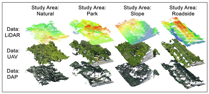
Overview of point clouds generated from the three data sources in the four study areas. LiDAR point clouds are coloured by height, UAV and DAP point clouds are coloured using natural colour contained in the images |
|
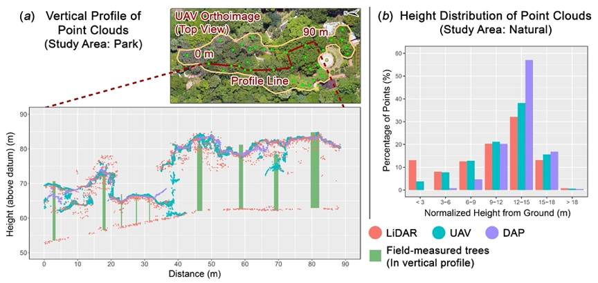
Characteristics of point clouds shown using (a) Vertical profiles connecting field-measured tree locations and overlaying remote sensing point clouds in the Park site, and (b) Percentage of points in different height classes for each remote sensing point cloud in the Natural site |
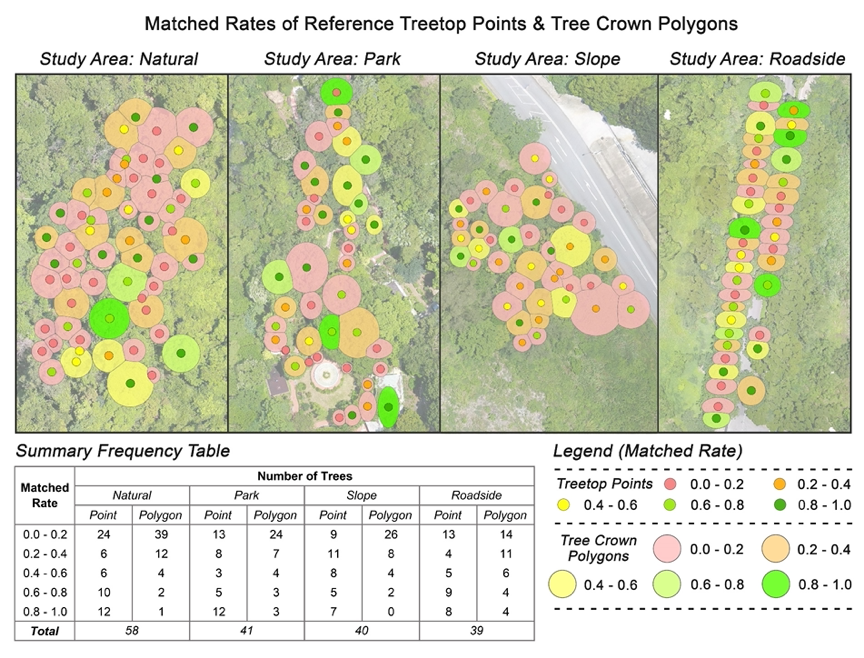
Matched rates of each reference treetop point and tree crown polygon, calculated as the ratio of “matched” cases out of the 24 cases implemented in this study |